
美国峡谷湖泊景观/Haecceitas Studio
发布于:
The canyon lake landscape
设计方:Haecceitas Studio
位置:美国 德克萨斯州
分类:滨水
内容:设计方案
图片来源:Haecceitas Studio
图片:13张

项目是关于领土概念构造的景观设计,它的灵感来自于扎哈·哈迪德早期的戏剧性画作、CJ Lim的构造景观和Sanford Kwinter的著作,Haecceitas Studio通过对这些内容的调查,构建了一系列方法,展示了多种意义的个体性景观。
在20世纪的最后一个季度,环保人士、独立组织,甚至政府也变得更加关心人类对环境的负面影响。作为建筑师,当务之急是我们要开始思考“建筑物”不是独立的实体和LEED“可持续”认证,而是一系列短暂的生物所生存的自然生态环境。如果我们在特定领域紧密结合地形进行设计,我们就能重新评估同时作为景观副产品及其映射的建筑语言。
同西德州一样,卢博克市尤其是典型的干旱平地类型。虽然表面上看起来是这样,实际上这个城市包含的各种各样的乡野景观似乎被忽视了。此外,卢博克市还有一个极其复杂的水系统,这个系统被不断的管理、维护,并根据自然流量的变化来提升系统。水的形成一方面是由于黄房子峡谷。这个河道贯穿了卢博克市,从城市西北角扩展至东南部到达兰瑟姆峡谷,而后继续流向克劳斯贝县。(虽然峡谷似乎起源于黄房子峡谷公园,河道本质上是从北克洛维斯开始的)。沿着峡谷,鉴于自然和人为作用,形成了一系列的8个峡谷湖泊。从西北到东南依次是:征服者湖、埃斯塔卡多湖、Comanchena湖、 麦肯齐河公园的峡谷湖、美湖公园的西蒙斯峡谷、邓巴湖、水牛泉和最后一个兰塞姆峡谷。卢博克市设置了一个30年期的议程,以期增强和重新定位这些峡谷湖泊的使用。
译者: 饭团小组
The concept of territorial architecture is a topic that questions various strategic understandings of complex site systems defined by conceptual ideologies, environmental implications, and identification of emerging phenomenal underlying patterns.
Borrowing influences from Zaha Hadid’s dramatic early paintings, the constructed landscapes of CJ Lim, and the writings by Sanford Kwinter, these investigations by Haecceitas Studio attempt to construct a series of methods, which will reveal the haecceity of multivalent landscapes. More images and architects’ description after the break.
Iterative processes of decoding internal and external territorial pressures initiate the formation of object and terrain self-reorganization and generation of emergent capacities. Throughout the development of articulation and orientation upon these fields, ‘objects’ are strategically controlled and locally expressed as adaptable, embedded architectural ‘organisms’, referring to a continuation of manipulation while maintaining a series of strict relational properties. Currently, this method is being tested on a series of eight Canyon Lakes in Lubbock, TX. Here you see this methodology thoroughly explored on the Llano Estacado Lake (lake 2). As we dissect the landscapes using tools such as mapping, data extraction, and field conditioning analysis we begin to understand more fully the hidden systemic networks operating along the draw at the local scale as well as the implications of phenomenal connectivity between ‘landscape’ and ‘city’.
During the last quarter of the 20th century, environmental activists, independent organizations, and even governments have become much more concerned with the negative impact of humans upon the environment. As architects, it is imperative that we begin thinking of ‘buildings’ not as independent entities and LEED ‘sustainable’ credits, but as a series of ephemeral organisms living amongst a natural ecological world. If we work through this tightly knit terrain within a specific territory, we can then reassess our architectural languages as both a by-product and as parallel projections of existing landscapes.
The pre-conceptions of West Texas and in particular, Lubbock typically falls into the categories of flat, and dry. Although this may seem the case on the surface, the city contains various sites of robust landscapes, which seem to go unnoticed. Furthermore, Lubbock in fact has an extremely complex water system, which is continuously being managed, maintained, and constantly morphing itself through natural flux. One aspect of this water formation is the Yellow House Canyon (or Draw). This channel slices through the City of Lubbock starting from the Northwest corner extending towards the Southeast reaching the body of Ransom Canyon, and then continuing on to Crosby County. (Although the canyon seems to originate at Yellow House Canyon Park, the channel essentially begins far North near Clovis.) Along the canyon, due to natural and manmade manipulations, a series of 8 canyon lakes are formed. From northwest to southeast: (1) Conquistador Lake, (2) Llano Estacado Lake, (3) Comanchena Lake, (4) Canyon Lake @ Mackenzie Park, (5) Canyon Lake @ Mae Simmons Park, (6) Dunbar Lake, (7) Buffalo Springs, and finally to (8) Ransom Canyon. The City of Lubbock has set a thirty-year agenda to enhance and re-purpose the use of these canyon lakes.
Our goal here in this project is to investigate the current conditions and future park implementation for not only each of the canyon lakes, but potentially begin to evaluate and understand the phenomenal connectivity between the 8 lakes. In order to focus the inquiry, the proposal is to define and construct a series of supplemental nodes at each of the eight sites. These nodes are developed as parallel studies into the complex topographic nature of these unnoticed dramatic landscapes. It is imperative to evaluate what a ‘public park’ means for Lubbock and how these sites can facilitate the necessary qualities for such an agenda. While fluctuating from the macro and into the micro scales, extracting, interpreting, prototyping, and iterating information creates new mapping derivatives. Furthermore, and most importantly, the project is directly intended to reverse develop the Southwest sprawl condition. The ‘zipper’ to make a tie to downtown and enhance socio-economic interaction is the foundation for such investigations.
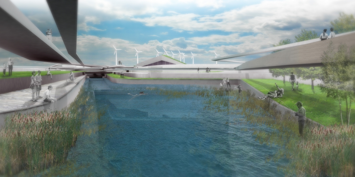
美国峡谷湖泊景观效果图

美国峡谷湖泊景观效果图

美国峡谷湖泊景观图解

美国峡谷湖泊景观图解

美国峡谷湖泊景观图解

美国峡谷湖泊景观图解

美国峡谷湖泊景观图解

美国峡谷湖泊景观图解

美国峡谷湖泊景观图解

美国峡谷湖泊景观图解

美国峡谷湖泊景观图解

美国峡谷湖泊景观图解
美国峡谷湖泊景观效果图

美国峡谷湖泊景观效果图
本文来源网络,版权归原作者所有,如有侵权请联系删除